The Singapore River is situated within the Central Region of the island city-state of Singapore. This historically significant waterway starts at Kim Seng Bridge and travels approximately 3.2 kilometres before emptying into Marina Bay. The river has been a central feature of Singapore’s geography and development, serving as the heart from which modern Singapore emerged.
In the past, the river was the epicentre of trade and commerce for the region, pivotal in establishing Singapore as an important port in Southeast Asia under British colonial rule. Today, the Singapore River continues to play a significant role in the country’s tourism sector. It winds through diverse neighbourhoods, past iconic quays like Clarke Quay and Boat Quay, conveying visitors and locals alike through the evolving story of the city.
As a city-state known for both its urban density and meticulous planning, the integration of the Singapore River into the landscape reflects a harmonious blend of history and modernity. The river, lined with a mixture of historical sites and contemporary establishments, offers a multifaceted experience of Singapore’s rich cultural tapestry and modern-day vibrancy.
Historical Significance
The Singapore River, a central artery in the city’s development, holds a storied past where colonial enterprises and burgeoning trade transformed a once quiet waterway into a bustling hub of commerce.
Colonial Era and Stamford Raffles
In 1819, Sir Stamford Raffles established a British trading post by the Singapore River, marking a pivotal turn for the area’s destiny. Raffles, representing the British East India Company, recognised the river’s strategic position for trade and sought to capitalise on its potential. This move by the British paved the way for Singapore River’s transformation into an active port, attracting merchants and establishing the city as a cog in international trade.
Trade and Commerce Evolution
Over the years, the Singapore River witnessed the surge of commerce and trade, evolving into a thriving port that contributed significantly to the economic growth of Singapore. By the mid-1800s, the area around the river, known today as Raffles Place, had developed into the commercial centre of the city. The Port of Singapore became known as a Free Port, with no customs duty chargeable on goods. The free trade policy attracted a mosaic of traders from across Asia and beyond, establishing Singapore as an integral node in seafaring trade routes.
Adjacent to the river, the Asian Civilisations Museum showcases this rich tapestry of the region’s history, including attestations like the Sejarah Melayu (Malay Annals) that provide insights into the pre-colonial significances and the layered history that unfolded along the water’s edge.
Geography and Environment
The Singapore River, central to the urban landscape of Singapore, flows through the city-state’s heart, contributing to both its ecological system and urban development.
River Course and Tributaries
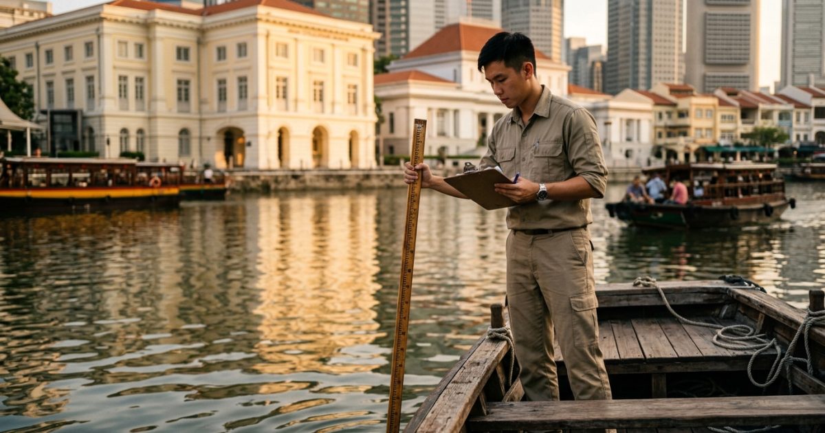
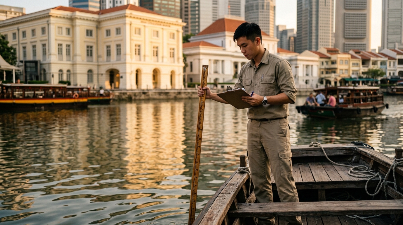
The Singapore River starts at Kim Seng Bridge and travels approximately 3.2 kilometres through the Central Region before emptying into Marina Bay. It’s worth noting that Alexandra Canal, historically considered part of the river, extends the waterway’s reach past its natural source. Urban development has seen the river largely bounded by concrete, with its course modified over the years by the Urban Redevelopment Authority to suit the needs of a growing city.
Biodiversity and Conservation Efforts
Singapore’s efforts towards conservation have seen the introduction of various initiatives to maintain and enhance the biodiversity along the river’s banks and within the Marina Reservoir. Once home to squatters and polluted, intensive cleanup efforts have transformed the waterway. It is now a habitat for wildlife, including families of otters that have become emblematic of Singapore’s successful balance of urbanisation and nature conservation. The river’s environment and the surrounding Singapore River Planning Area are continually managed to ensure the sustainability of its ecosystems within this highly urbanised setting.
Cultural and Social Aspects
The Singapore River is not just a geographical landmark but also a hub of cultural and historical significance, which continues to evolve with time, offering a mix of heritage and modernity.
Historical Quays and Landmarks
Clarke Quay, Boat Quay, and Robertson Quay are the historical quays that play a pivotal role in the evening life of the river. Each quay has its unique character; Clarke Quay is renowned for its vibrant nightlife, Boat Quay for its riverside dining, and Robertson Quay for its more relaxed atmosphere. Notable bridges such as Cavenagh Bridge, Elgin Bridge, Coleman Bridge, Read Bridge, and Jubilee Bridge connect these precincts, making them easily accessible and forming a historical journey along the Singapore River.
- Cavenagh Bridge: Built in 1869, it is Singapore’s oldest bridge and stands as a testament to engineering marvels of the colonial era.
- Elgin Bridge: Named after a British Governor-General, it marks the boundary between the chinatown and the core of the colonial district.
Adjacent to these quays are important landmarks such as the Merlion, a symbolic sculpture of Singapore’s heritage, and districts like Chinatown and Kampong Gelam, which are culturally rich and historically significant.
Contemporary Lifestyle and Attractions
The Singapore River today is a snapshot of the city-state’s modern lifestyle and its commitment to the arts. The Civic District is the centre of arts and cultural experiences, where historic buildings have been preserved and repurposed to house various artistic endeavours. The transformation of the river post-clean up has led to a thriving leisure and entertainment scene. Sculptures dotting the river banks tell stories of historical events and people, adding an educational layer to the visual aesthetics of the location.
The Esplanade Bridge offers a panoramic view of the bay area, making it a popular spot for photography enthusiasts. Visitors and locals gather here for a diverse mix of activities that often spill over to the adjacent Esplanade — Theatres on the Bay, a waterside building known for its distinctive architectural style and for hosting a wide array of performances. The river banks are frequented by people looking to unwind, drawing an eclectic crowd that contributes to Singapore’s global city image.
Economic Development
The economic landscape of the Singapore River has significantly evolved, transitioning from a bustling trading hub to a symbol of modern economic prowess, heavily influenced by its infrastructural advancements and growing tourism sector.
From Trading Hub to Modern Economy
Historically, the Singapore River served as the heart of the city’s economic activity, establishing itself as a crucial entrepôt port. Trading ships from diverse regions anchored here, exchanging a myriad of goods. Flourishing as a vital trade artery, the riverbanks were lined with shophouses and the trading offices of Chettiars, a community known for their financial services. The notable Asian Civilisations Museum, near the river, now embodies the cultural impact of these formative years of commerce.
Moving into contemporary times, the river vicinity continues to be a centre of financial activities but with a more sophisticated structure. High-rise buildings accommodate corporate offices, and the financial industry is complemented by retail and entertainment sectors. Collyer Quay and Clifford Pier are exemplary of this progress, showcasing where tradition meets modernity.
Infrastructural Advancements and Tourism
Investment in infrastructure around the Singapore River has fostered significant developments in tourism, turning the historic trade channel into a recreational delight. Visitors can experience the cultural history through a river cruise that offers views of the antique shophouses and the iconic Singapore Stone. This activity not only highlights Singapore’s storied past but also contributes to its economic diversification.
On land, the transformation is marked by areas such as Boat Quay and Clarke Quay that have seen a remarkable conversion. Once packed with bumboats and cargo, these quays now host vibrant eateries and hawkers, offering both local and international cuisines, thereby melding culinary offerings with cultural experiences. As Singapore advances, its river symbolises sustainable development while honouring its historical significance.
Modern Challenges and Solutions
Managing the Singapore River’s environmental and urban developmental challenges requires continuous effort and innovative solutions. Both the preservation of the environment and the optimisation of urban space are critical to maintaining the river’s health and relevance.
Environmental Initiatives
Singapore has implemented comprehensive environmental initiatives to address the challenges of pollution that once degraded the Singapore River. Policies have been enforced to manage domestic and industrial waste. The initiatives include:
- Relocation of polluting sources.
- Strict law enforcement to prevent illegal dumping.
- Wastewater treatment facilities to manage sewage discharge.
- Public education programmes like ‘The Clean Rivers Education Programme’ to cultivate community support.
Urban Planning and Public Spaces
Urbanisation in Singapore brings unique challenges such as the balance between economic development and environmental sustainability. The Urban Redevelopment Authority (URA) plays a pivotal role in accomplishing this through thoughtful urban planning and the creation of inclusive public spaces.
Public housing initiatives ensure residential areas complement river spaces, turning the vicinity into vibrant communities. Skyscrapers and commercial buildings are strategically placed to enhance the skyline while ensuring environmental impact is minimised. URA’s emphasis on incorporating green public spaces allows the citizenry to engage actively with their river, promoting its cleanliness and vitality.
Connectivity and Infrastructure
The Singapore River’s infrastructure has notably evolved, featuring several bridges that connect its history with its present ambition.
Bridging the Past and Future
The network of bridges spanning the Singapore River serves as significant conduits that facilitate not only pedestrian and vehicular movement but also symbolise the city-state’s journey from a colonial trading post to a global financial hub.
Cavenagh Bridge, as one of the oldest bridges, stands testament to Singapore’s colonial era while continually adapting to modern use. It is currently designated for pedestrians, linking the commercial district with the cultural areas of the riverbank. Adjacent to it, Anderson Bridge represents the architectural finesse of the Edwardian period, adding aesthetic value while supporting the city’s transportation needs.
Near the river’s source, Kim Seng Bridge marks the transition from freshwater to saltwater, adjoining to Alexandra Canal, an essential waterway that contributes to the river’s network. In tandem with this, Clemenceau Bridge and Alkaff Bridge meld functionality with style – while the former efficiently directs the busy flow of traffic, the latter displays vibrant colours, reflecting Singapore’s dynamic arts scene.
Elgin Bridge serves as another crucial link, providing a crossing for one of the busiest parts of the river. Each of these structures not only supports connectivity across Singapore’s Central Region but also interprets the city’s layered history through their distinct designs and the roles they play within the urban landscape.
Singapore River Frequently Asked Questions
Is Singapore River a real river?
The Singapore River is undeniably a real river situated in the heart of Singapore’s central region. As a natural watercourse, it is 3.2 kilometres long, flowing from its source near Kim Seng Bridge through the island’s bustling cityscape before culminating into Marina Bay.
Historically, this river has been pivotal in Singapore’s development. The presence of the Singapore Stone with ancient inscriptions suggests a rich heritage dating back to the river’s origins. Along its course, it transitions into Alexandra Canal, extending its reach a further two kilometres.
With its transformation over the years from a busy port to a vibrant lifestyle hub, some might question its authenticity as a river. Yet, the Singapore River remains a geographic feature defined by its natural formation and continuous flow, maintaining the characteristics essential to being considered a river.
Today, residents and tourists frequent its banks, observing the juxtaposition of calm waters with the dynamic city backdrop—a testament to the Singapore River’s enduring reality amidst urban evolution.
Where does the Singapore River flow into?
The Singapore River ends in the Marina Reservoir, in the southern part of the island. The river spans approximately 3.2 kilometres from its source until it reaches the reservoir.
Commencing from its origins near the Alexandra Canal, the river flows through the central area of Singapore, where it has served both historical and economic functions. The river’s journey through Singapore’s urban landscape is integral to the nation’s cultural and social identity.
As the Singapore River approaches its culmination, it empties into the Marina Reservoir. This reservoir is a critical component of Singapore’s freshwater resources, crafted by the Marina Barrage which strategically converts the basin into a freshwater reservoir.
The Marina Reservoir, functioning as a catchment area, is not only pivotal for water supply but also serves as a popular recreational space, providing a scenic backdrop to numerous activities and festivities. The integration of the river into this reservoir is a testament to Singapore’s innovative approach to urban water management and land utilisation.
This transformation into a freshwater reservoir marks the completion of the Singapore River’s path, melding history with modern development, as it flows through the heart of Singapore.
How did Singapore clean up the Singapore River?
The clean-up of the Singapore River was an extensive endeavour that spanned a decade, from 1977 to 1987. It was initiated by the then Prime Minister, Lee Kuan Yew, with the vision of transforming the heavily polluted waterway into a clean and vibrant part of the city.
Key Actions in the Clean-up Process:
- Waste Management: Industries along the river were identified as major polluters, dumping waste and used water directly into the river. Regulations were put in place to cease these practices.
- Rubbish Removal: Intensive efforts were made to clear rubbish from the Singapore River. This included the removal of debris floating on the water’s surface and the dredging of the riverbed to address accumulated waste.
- Relocation of Vendors and Squatters: To prevent future pollution, hawkers, vendors, and informal settlers along the riverbanks were relocated.
- Infrastructure Improvements: Improvements in infrastructure played a crucial role. Public utilities and sewerage systems were expanded to manage domestic waste effectively.
- Legislation: Strong legislation was enacted to prevent future pollution of the River, including fines and penalties for non-compliance.
The results of this multi-faceted approach yielded a transformed Singapore River, turning it from a polluted waterway into a clean and attractive spot that now supports leisure and commercial activities. The clean-up also paved the way for further developments like the Marina Barrage, contributing to Singapore’s reputation for urban sustainability and planning.
What is so special about the Singapore River?
The Singapore River holds a pivotal place in Singapore’s history. This river is deeply intertwined with the nation’s growth, evolving from a bustling fishing village into a vibrant hub of trade, commerce and finance.
Historical Significance
- The Singapore River’s mouth was the site of the old Port of Singapore.
- The surrounding area played a central role in Singapore becoming a British trading port.
Cultural Impact
- The river has been the lifeline of the city, influencing its landscape and people.
- Elements of Singapore’s multicultural heritage are evident along its banks.
Transformation
- Through massive clean-up efforts, the Singapore River saw a dramatic transformation from its previously polluted state to the clean waterway it is today.
- The river’s renewal is often cited as a testament to Singapore’s commitment to environmental sustainability.
Current Day
- Along the river’s banks sit historical quays, such as Collyer Quay. These areas preserve a glimpse into the past amidst modern developments.
- Today, the Singapore River thrives with activity, from waterside dining to bustling entertainment venues.
Attractions
- The river is flanked by landmarks, such as the Merlion, symbolising Singapore’s humble origins as a fishing village—once called Temasek.
- It also features iconic bridges that not only serve as functional crossings but also add to the river’s aesthetic charm.
The specialness of the Singapore River lies not only in its history or its transformation but also in its continued importance to the spirit and urban landscape of Singapore. It’s a living reflection of the city’s journey from past to present.
What is the Singapore River used for today?
Today, the Singapore River serves primarily as a hub for leisure and entertainment. Once the heart of trade, the river’s banks have been transformed into a vibrant nightlife scene.
Leisure Activities:
- Dining: Riverside restaurants and cafes provide diverse culinary experiences.
- Nightlife: Bars and clubs along the riverfront offer vibrant spots for socialising.
- River Cruises: Tourists and locals can enjoy river taxi services and boat tours, offering unique perspectives of the city’s skyline.
Cultural Significance:
- The river is home to historical monuments and sites, where visitors can engage with Singapore’s rich heritage.
Economic Role:
- While not the centre of commerce it once was, the river remains economically significant due to its influence on tourism and the hospitality industry.
Urban Development:
- The Singapore River reflects urban renewal, with adaptive reuse of historical buildings for contemporary purposes.
Environmental Focus:
- Attention to sustainability and cleanliness remains a priority to preserve the river’s health and appeal.
This location’s transformation from an industrial past to a modern leisure destination exemplifies Singapore’s commitment to development while maintaining cultural reverence.
Is Singapore River man made?
The Singapore River is a natural feature that has been significantly altered by human intervention, although it is not entirely man-made. Its origin is at Kim Seng Bridge, with flow stemming from the Alexandra Canal. Historically, the river has served as a central artery in Singapore’s development, both commercially and culturally.
Natural Formation:
- The river’s original path was formed by natural geography.
- It has undergone alterations to support urban development.
Human Modifications:
- Alexandra Canal: An extension of the river, which has been developed to manage water and prevent flooding.
- River Clean-Up: Efforts in the late 20th century have significantly changed the river’s ecology and aesthetics, effectively transforming it.
Urban Infrastructure:
- Quays along the river have been redeveloped for commercial and recreational use, changing the natural landscape.
- River taxis and boats utilise the river, indicative of human-centric utilisation.
In essence, while humans have heavily modified the Singapore River to suit their needs, its original existence is a product of natural processes. Therefore, it cannot be classified as a man-made river but rather a natural waterway with substantial anthropogenic influence.
How many rivers are in Singapore?
Singapore, though a small island nation, is home to a network of over 30 rivers and canals. The Kallang River is recognised as the longest river on the island with an approximate length of 10 kilometres.
Here’s a list of some notable rivers in Singapore:
- Singapore River: Renowned for its historical significance, it flows for around 3.2 kilometres before entering Marina Bay.
- Kallang River: Stretches for 10 kilometres and is the lengthiest river in Singapore.
- Rochor River: A shorter river known for its proximity to the urban area.
Other rivers include:
- Sungei Bedok
- Sungei Punggol
- Sungei Seletar
- Sungei Serangoon
The rivers in Singapore have played a significant role in the country’s development and are integral to its drainage system, preventing flooding in the highly urbanised environment. They also serve as scenic waterfronts and recreational areas, enhancing urban spaces and providing habitats for local wildlife.
Does Singapore have natural rivers?
Singapore boasts a number of natural rivers that meander across the island despite its highly urbanised landscape. The most prominent among these is the Singapore River, which flows approximately 3.2 kilometres from its source at Kim Seng Bridge to Marina Bay. It’s been an integral part of the country’s history, once bustling with trade and commerce.
Apart from the Singapore River, the Kallang River stands out as the longest river in Singapore, spanning 10 kilometres from the Lower Peirce Reservoir to the Kallang Basin. It has played a significant role in the country’s drainage system and recreational activities.
In addition to these, there are several smaller streams and rivers located on offshore islands like Pulau Tekong and Pulau Ubin. These waterways, such as Sungei Belang and Sungei Jelutong, though lesser-known, are still an essential aspect of Singapore’s natural water bodies.
The natural rivers in Singapore serve various functions, from supporting biodiversity to offering recreational spaces for the public. These rivers have undergone extensive clean-up and are now focal points for leisure activities, although swimming is typically not permitted for safety and health reasons.
List of Some Natural Rivers in Singapore:
- Singapore River
- Kallang River
- Pulau Tekong and Pulau Ubin rivers
- Sungei Belang
- Sungei Jelutong
- Sungei Mamam
- Sungei Puaka
These rivers, alongside others, confirm Singapore’s geographical features that include natural waterways contributing to the country’s unique hydrography.
Where does Singapore River start and end?
The Singapore River flows through the heart of Singapore, a nation renowned for its rapid transformation from a fishing village to a bustling metropolis. It begins its journey as Alexandra Canal, upstream from the Kim Seng Bridge, and meanders southeast for about 3.2 kilometres before meeting the Marina Bay.
Origin of the River:
- Starting Point: Alexandra Canal
- Initial Landmark: Kim Seng Bridge
Journey of the River:
- Travels through Singapore’s Central Region
- Passes historic neighbourhoods and modern developments
Termination of the River:
- Ending Point: Marina Bay
- Significance: The confluence represents a mix of Singapore’s heritage and its contemporary status as a global city.
Alongside its banks, various tributaries and canals feed into the Singapore River, each contributing to its flow and significance. The river has played a pivotal role in the city-state’s past, serving as a lifeline for commerce and daily living, and continues to be integral to the urban landscape.
Can I Swim in Singapore River?
Swimming in the Singapore River is not recommended due to safety and water quality concerns. Historically, the river played a crucial role in the strategic trading position of Singapore. However, its usage has shifted over time.
While the river has undergone extensive clean-up efforts since the 1970s, transforming into a fresher body of water suitable for recreational activities, swimming is not permitted. The focus has been on creating a vibrant commercial and leisure environment, rather than making it a swimming destination.
Reasons swimming is not recommended:
- Pollution: Despite clean-up efforts, urban waterways are susceptible to pollution.
- Boat Traffic: The river sees a significant amount of boat traffic, particularly from tourist cruises, making it unsafe for swimming.
- Official Regulations: There may be local regulations in place that prohibit swimming for safety reasons.
Nearby swimming alternatives include:
- Public Pools: Designated public swimming pools are available throughout Singapore.
- Open Water: Locations such as Lazarus Island provide supervised open-water swimming opportunities.
Authorities encourage enjoying the Singapore River through guided tours, scenic walks, and cruises, which allow individuals to appreciate the river’s beauty safely and responsibly.